Princeton University - A Land Developer
Following the Second World War, Princeton University purchased large land parcels in Plainsboro and the surrounding communities with the objective of developing the properties. This acquisition activity peaked in the 1980's when, the University owned almost 5,000 acres in the Princeton area (up from its original 4.5 acre campus).
In 1973 the University took a portion of the land on the east side of US 1 to create the Forrestal Center, a large commercial office and research park. It is one of the largest such parks in the country. Several major corporations have offices in the park, most recently Novo Nordisk.
The Robert Wood Johnson Foundation, one of the richest in the world, was the first occupant, purchasing 70 acres in 1975. In 1984 the University bought 108 acres from St. Joseph's Seminary on the west side of Route 1 and gave a long term lease to a developer to build the Forrestal Village Shopping Center and Office Complex.
The last Plainsboro property to be purchased by the University occurred in 1986 with the acquisition of 450 acres from Princeton Nurseries at a cost of $31 million. The University intended to develop the property with another office complex. But strong opposition from the town of Kingston and environmentalists stalled the project.
The James Forrestal Campus provided research laboratory space for several government funded projects including an atomic reactor and a hovercraft project. The reactor is gone, but the dome shaped building can still be seen a short distance east of Schalks Crossing Road. An Airplane runway and wind tunnel, used for aircraft research, were located on the property until the mid 1980's. All that remains is the helicopter landing pad.
The Campus today houses a number of academic departments, the Princeton Plasma Physics and Geophysical Fluid Dynamics Laboratories and various projects of the School of Engineering. PPPL is currently engaged in testing the feasibility of using nuclear fusion to produce electricity and is funded by the US. Department of Energy. GFDL, funded by the U.S. Weather Bureau, investigates the mechanism controlling the behavior of the oceans and the atmosphere.
Princeton Landing - The Land
In 1976, Princeton University sold 94 acres, between US 1 on the east and Mapleton Road on the west, to a developer, to create Princeton Landing. The history of the property can be traced back to pre-Revolutionary times.
Matthias Van Dyke, the first owner of the property migrated from the Dutch settlement of New Amsterdam (now known as Manhattan). In the early 1700's Matthias acquired some two thousand acres along the Millstone River from the English Crown for a farm. In 1742 he constructed a stone house, slave quarters, and several large barns on the property. Upon his death the property was divided among his seven sons. His son Peter inherited 862 acres. Princeton Landing is located on a small part of the Peter Van Dyke farm. Peter and his wife Elizabeth are buried in a small plot in Parcel 7 (discussed later).
The Van Dyke house still remains on Mapleton Road north of the St. Joseph's Seminary. The house is lived in by William Flemer Jr., the owner of Princeton Nurseries.
In the late 1800's, the Van Dyke farm was sold to the Root family, who built a 12 room house on a bluff (now in Parcel 6) that overlooked the canal and lake. In 1914 the Rockefeller Institute for Medical Research purchased the farm.
In 1910, William Flemer Sr. purchased several contiguous farms to create Princeton Nurseries. The nursery rented a portion of the Institute property and several other properties in other parts of Plainsboro, Mercer, Middlesex, and Somerset counties. Princeton Nurseries became the largest plant nursery in the world shipping plants throughout the world. In 1986, the Flemer family sold a large part of the property to Princeton University. Many of the trees planted by the nursery can be seen on Princeton Landing property.
Currently Princeton Nurseries owns over 5,000 acres, most of which is in Allentown. The nursery continues to operate a large number of greenhouses along Mapleton Road and to rent several other properties in the area.
Princeton University purchased the Rockefeller Institute property in 1950. Princeton Landing is located on a portion of the western part of the property and the Forrestal Campus of the University in located on the eastern portion of the property.
A few of the Rockefeller Institute buildings still remain, including the Smith House (discussed later) and some of the Forrestal Campus buildings. The Root house and several other structures were torn down by the developer of Princeton Landing. One house that stood at the main entrance to Princeton Landing was moved by Bill Flemer to the Nursery. It can be seen next to the Van Dyke house on Mapleton Road.
The gate at the end of the road leading to Mapleton Road was built by the Institute and had a small gate house located next to it. There were animal barns on both sides of the road leading from Mapleton Road up to the Smith House. The road then passed the Smith House and intersected with State Road 26 (now US 1). A small tunnel under Route 26 continued the road to the east side and the main Institute buildings including a power generating plant, which still remains. The tunnel was replaced by a two-lane underpass in 1932 and the road lowered another 4 feet to allow trucks to pass under the road. A large pipe passing through the underpass marks the original depth of the tunnel.
Up until the early 1970's US 1 was largely a divided rural highway with a grass strip down the middle. It passed through sod farms, nurseries, dairy farms and scattered homes. In 1979 the center grass island was replaced with a much safer three foot high concrete barrier. The Scudders Mill Road was completed in 1984. The College Road Overpass was completed in 1989. The New Jersey Department of Transportation is currently widening US 1 to three lanes in each direction with an overpass for Scudder's Mill Road. The intersection at Plainsboro Road will be closed to crossing to and from Mapleton Road. This work should be completed in 1996.
Princeton Landing is surrounded by 100 acres of property owned by Princeton University. A little over half of this land is to the south with the remainder on the other three sides. The Princeton Landing nature trail is located on the southern part. The trail is atop the perimeter of a detention basin constructed by dredging from Lake Carnegie. It handles Princeton Landing water overflow from major storms.
Princeton University has agreed to reserve this land as "common open space lands available for the use and enjoyment of the owners and residents of Princeton Landing." This is in conformance with a Plainsboro Township zoning ordinance requiring one acre of common open space to be set aside for every eight dwelling units.
The Forrestal Village Shopping Center and Office Complex borders Princeton Landing on the northeast, on land owned by the University. The University has leased 45 acres bordering Princeton Landing on the northwest, to the Continuum Care Corp. Wellesly MA, a subsidiary of the Mediplex Group. The land will be developed into a senior citizen housing complex and continuing care facility. The developer plans to build 120 town houses, 156 apartments, an 80-unit limited care building, and a 180-bed nursing home. This is still being reviewed by the Plainsboro Planning Board and if approved, construction may begin this year.
Princeton Landing - The Community
In 1977, the developers, Sarshik & Edwards (doing business as the 20th Century Construction Co.) and the University received permission from the Township of Plainsboro to construct a development of 600 homes. The developer and the University promised that 20 percent of the residential units would be low income housing, 40 percent for middle income and 40 percent for higher income residents. The provision for low income housing conformed to a Middlesex County requirement that Plainsboro provide such housing. It also enabled the developer to obtain low-interest financing from the University and HUD subsidies.
Sarshik & Edwards began construction of "Forrestal Village" in early 1979. It consisted of 120 rental apartments (Parcel I) and 68 townhouses (Parcel II). The apartments were to be available to low income qualifiers but few ever lived in them. The apartments were quickly rented and the townhouses sold out. However, it took the developer over two years to construct the homes.
By 1980, the developer was in financial trouble and sold Parcels II-XII to the Abramson Corporation, doing business as Landing Associates. LA promised to complete construction by 1990. It appears that they may complete the project by the end of 1995. In 1986, the Abramson Corporation, doing business as Landing Associates purchased Parcel I, converted it to a condominium, and renamed it "The Commons at Princeton Landing." The Forrestal Village Community Services Association Inc. (FVCSA) was created by the developer as a Homeowners Association to operate Princeton Landing. The community consists of 600 living units and is divided into twelve parcels, as shown below. Owners of all units are members of the Association and have equal voting rights.
| Parcel |
No. of Units |
Parcel |
No. of Units |
| I |
120 |
VII |
47 |
| II |
68 |
VIII |
28 |
| III |
44 |
IX |
36 |
| IV |
50 |
X |
38 |
| V |
42 |
XI |
36 |
| VI |
47 |
XII |
44 |
The homes are owned in what is referred to in the real estate industry as a "fee simple form of ownership with an automatic homeowners association." The Commons is a condominium.
Each Parcel operates as an autonomous body with its own budget*. The Association has a board, with seven non-paid elected resident members, that runs Princeton Landing. The Board hires a property management company to handle the accounting and all the day-to-day operation of Princeton Landing.
* Bounded by the articles common to all and governed by the Board. The Board is advised by several committees. The exception being the Covenants Committee.
After whom is Sayre Drive named?
Sayre Drive is named after Daniel Clemens Sayre (1903-1956), the first Chairman of the Aeronautical Engineering Department at Princeton University. Sayre, in 1951, spearheaded the University's efforts that led to the acquisition of the Rockefeller Institute property and development of the Forrestal Campus. Sayre served as the first director of the Forrestal Research Center until his untimely death in 1956. In his memory, one of the buildings on the campus was named Sayre Hall and the road leading from the research area, under US 1 to Mapleton Road was named Sayre Drive.
The Smith House
The Smith House was constructed in 1914 by the Rockefeller Institute. It served as the home of the Institute's Director, Dr. Theobald Smith (1859-1934). He lived in the home until his retirement in 1928. It then served as the Institute headquarters until the property was sold to the University in 1950.
Princeton University first used the Smith House as a base of operations for a classified research project operated by RCA and Allis-Chambers, involving the peacetime use of nuclear energy to generate power. Subsequently the building was used as offices for visiting students and scientists. It also served as the administrative offices of the Princeton Forrestal Center.
The developer of Princeton Landing used the Smith House as a sales office. In June of 1989 it was turned over to the Homeowner's Association. The developer claims to have invested $750,000 to renovate the 8,000 square foot building to serve as the community clubhouse and Association offices.
The Princeton Landing Cemetery
A small family burial plot exists on Princeton Landing property. It contains the graves of Elizabeth Van Dyke (died in 1826 at the age of 70) and Henry Van Dyke (died in 1816 at the age of 63). The two massive headstones were stored by the Plainsboro Historical Society while Princeton Landing was under construction. The Society also had the stones refurbished by Columbia University. The 12 foot by 12 foot site is enclosed by tall shrubs and is located in Parcel 7, just behind unit 310. The stones were originally upright, but now have been laid down on the ground.
St. Joseph's Seminary
St. Joseph's Seminary is located on 55 acres that adjoins Princeton Landing on the northwest. It straddles both sides of Mapleton Road and extends down to the canal. It was established in 1912 by the Congregation of the Mission (Vincentian Fathers). The Seminary originally owned 180 acres of land. In 1962 they sold to the University a 17 acre parcel on the east side of US 1. In 1986, they sold to the University 108 acres between the Seminary and US 1. The University developed part of the property into the Forrestal Village shopping center and office complex. Another portion will be developed into a retirement community and continuing care facility.
Several of the Seminary's buildings were built of stone taken from a quarry located opposite the Seminary, between Mapleton Road and the canal. When the land was quarried out the pit was filled in. The remaining stone was obtained from the same vein that continued on the west side of Lake Carnegie to the Delaware River.
Originally known as St. Joseph's College, the seminary provided training for the priesthood. Later, its functions were transferred to Niagara University and it became a preparatory high school for boys considering becoming priests. The school ceased operation in 1992 and became a retreat center operated by the Vincentian Fathers. It is used by Catholic and Protestant congregations. Fifteen Vincentian priests reside in the buildings. The Vincentian Order intends to retain the property.
The Seminary today consists of several buildings, the finest of which is the Queen of Miraculous Medal Chapel. Construction was begun in 1932 and completed in 1934. It is an exquisite example of the Gothic architectural style. Its appointments are of the finest artistry and quality and contain a vast amount of metal work that many consider among the most outstanding in the country. There is a crypt below the chapel with several additional altars.
Lake Carnegie
During the 1800s the Princeton University rowing team practiced on the congested Delaware and Raritan Canal. Because of the barge traffic on the canal, this proved difficult and dangerous, causing the sport to be dropped in 1884.
In 1902, Andrew Carnegie, accompanied by Howard Russell Butler, a well-known painter and Princeton University graduate, came to Princeton to see Grover Cleveland, then ex-President of the United States. He also visited the University and, when informed of the rowing team's problem and a dream Butler had for creating a lake on the Millstone River, for the rowing team to practice, offered to provide $135,000 for the project. Woodrow Wilson, then President of the University, accepted hoping to obtain funding also for more essential purposes. Wilson later remarked "We asked Carnegie for bread, and he gave us cake."
Butler managed the three year project. It ended up costing $450,000, most of which came from Carnegie, and the rest from donations.
Thirty-one pieces of property comprising over 400 acres of land were purchased, including Scudder's Mill, a blacksmith's shop, and the small settlement of Aqueduct (most of which is now under water). The Pennsylvania Railroad, owners of the canal, donated 110 acres on the east side of the river. The three-and-a-half mile long lake was created by damming the Millstone River at Kingston and by excavating the marshy land that bordered the Millstone River and Stony Brook, which joined at the settlement of Aqueduct (just north of Harrison Street). New bridges also had to be built at Harrison Street and Washington Road. Harrison street, which originally turned and ran along the canal to Mapleton Road was rerouted to intersect with US 1.
In 1906, when Carnegie attempted to donate the lake to the University, the offer was rejected owing to provisions in the University charter. Thus, the Carnegie Lake Association Inc., was formed to own the lake. This assured the University the full use of the lake without assuming the liability for it.
The Delaware & Raritan Canal
Princeton Landing, on its west side, overlooks the Delaware and Raritan Canal and Lake Carnegie. The canal and a single track railroad were begun in 1830. The railroad was completed in 1832 and the canal opened for traffic in 1834. The 75 foot wide and eight foot deep canal was dug by hand, mostly by Irish immigrants. From New Brunswick, the 44 mile long canal followed the Millstone River to a point just north of Harrison Street. It then followed Stony Brook down to Province Line Road. From there it cut across the county, passed through Trenton to join the Delaware River at Bordentown. A 22 mile long feeder canal began on the upper Delaware and joined the main canal in the center of Trenton.
The canal was built primarily to move coal from the mines in Pennsylvania to New York City. Barges, drawn by mules, also moved lime, gravel, produce and manufactured goods along the canal. In addition to freight, a passenger service by "packet" existed. At night the bells on the patient mules could be heard tingling as they trudged on the tow path. The mules were supplemented by steam powered barges beginning in 1843.
The eight lock of the canal, which began the decent to New Brunswick, and the lock tender's house still exist just north of Princeton Landing. They can be seen today just off Route 27 in the town of Kingston. The lock has been replaced by a sluice gate. In its day the lock would allow barges to be raised and lowered eight feet. There also were swing bridges located along the canal at Route 27 and Harrison Street. When a barge came through, the bridges were pivoted away to open the canal passage. The swing bridges were replaced by stationary bridges after the second World War.
The single track Camden-Amboy Railroad, along the east side of the canal served as the main line from New Brunswick to Trenton. It was primarily a
passenger railroad and during the Civil War carried troops. In 1862, the Pennsylvania Railroad began construction of a new main line with dual tracks that ran directly from Trenton to Jersey City. The railroad tracks along the canal were removed and used to construct sidings for the new main line. Mapleton Road, which was a narrow carriage road was widened to cover some of the railroad bed.
In 1910, a tunnel under the Hudson River was built providing a direct high speed route from Philadelphia to New York City. Traffic on the canal diminished and on June 12, 1934 the canal ceased operation. It was then taken over by the State of New Jersey for water conservation and in 1972 became a state park. The canal, as a mode of transportation, functioned for one hundred years.
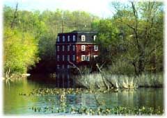
| If you go to visit the site immediately south of Route 27, also take a look at the old stone bridge. It was built in 1789 to replace a wooden bridge destroyed by Washington's troops retreating from the advancing British during the Revolutionary War. Walk across the bridge to see the three-story former Kingston flour mill, built in the mid 1800s (now a residence) on the site of two earlier mills. |
|
To the right of the mill is a small brick building that contained a steam engine to generate power for two of the mill stones (only one ran on water power). Notice also the railroad tracks that were laid in the late 1800s for a line that ran from Rocky Hill, through Kingston where it turned to join the Pennsylvania Railroad main line at Monmouth Junction. It was used until the early 1970s by the Trap Rock Quarry, just north of Kingston.
Some Plainsboro History
The Army Corps of Engineers, in surveying the site for Scudder's Mill Road, found artifacts which led to an archaeological dig in 1982 (a copy of the report can be found in the Plainsboro History Room). The dig produced knives, charcoal, charred hickory nuts, hammers, fish spears, post holes, and various projectile points. "Fire-altered" stones that had apparently been used for cooking, were also recovered. Testing of these artifacts indicated that the site was inhabited as far back as 1700 BC. Prehistoric tribes are believed to have roamed the area as far back 9000 BC 9000BC. The Lenni Lenape (Delaware) Indians lived in the area from around 1623 AD to 1623AD.
|
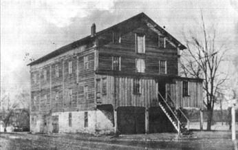
Scudders Mill
A grist mill, saw mill, and fulling mill.
It was located in the middle of what is now Carnegie Lake, near the aqueduct on Mapleton Road. A monument is now located near its location.1890s
Photograph circa 1890's |
|
Three quarters of the Revolutionary War battles were fought in New Jersey and the commonly battles that are commonly considered the turning point of the Revolution were fought near here. On December 24, 1776 General Washington and his troops crossed surprised Delaware River and surprised the British troops and defeated them at the battles of Trenton and Princeton**.
The British and American troops traveled back and forth through Kingston and Princeton on Route 27, then known as the "Kings Highway," and occupied the Van Dyke home, which still stands on Mapleton Road.
In 1834 the New Jersey Gazetteer described "Plainsborough" as a "habitat..consisting of a tavern, a store, and eight or ten buildings." In 1960 the population stood at 1,198 rising to 1,640 in 1970. The current population is well over 16,000.
|
|
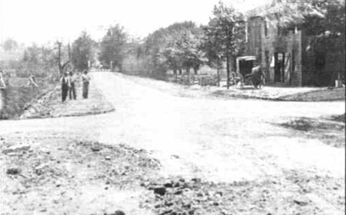
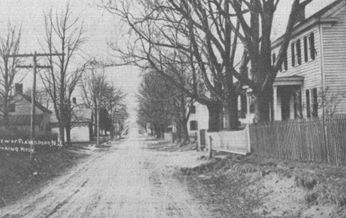
| Junction of US 1 and Plainsboro Road facing south toward Trenton after state bought it from a private toll road company. |
Plainsboro Road looking west toward Route 1. Circa 1910 |
After Cranbury township refused to fund the construction of a new school, area residents applied to the State to establish a new township. In 1919 Plainsboro Township was created from portions of South Brunswick and Cranbury townships. For many years high school students were bussed to the Princeton High School. When Princeton decided to no longer take students from outside the community, it resulted in the creation of the West Windsor-Plainsboro Regional School District.
When the Pennsylvania Railroad main line was constructed1800s in the late 1800's, it came through Plainsboro and a station existed at the present location of the Plainsboro Shopping Plaza. Train service was 1960s in the 1960's. A trolley line was built 1900s the early 1900's that connected Newark and Trenton and passed through Plainsboro. The line was abandoned in 1935. The Public Service high tension lines now follow the route.
Plainsboro, with its fertile soil, good drainage, moderate climate, and abundant water sources, early on developed into a prosperous farming area. The early Dutch farmers commonly used slave labor (primarily indentured servants). The farms were very self-sufficient and produced mainly grain. By 1800 the large farms were broken up into smaller farms. With the coming of the railroad and canal in 1834, the farms began supplying Philadelphia and New York City with meat and produce of all kinds.
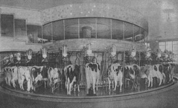
Plainsboro for many years was the home of the Walker-Gordon dairy farm, which moved here in 1897. It was the largest certified raw milk producer in the world. For a while there were more cows in Plainsboro than humans. Walker-Gordon constructed a building housing a huge turntable on which cows were milked automatically. The structure was known as the Rotolactor.
The Rotolactor was a merry-go-round and the cows were the riders. The cows first walked through an area where they were scrubbed clean and then on to the revolving platform where their udders were wiped. They were hooked up, milked, rode around, unhooked, and led off with nary a beat missed.
For many years, the building was a tourist attraction, visited by many school children. The farm, the entrance of which is on Plainsboro Road, closed in 1971. In the near future the land will become a housing development. In the meantime one can visit the site and see the headstone for Elsie, the original Borden cow. |
|
** The Princeton Battlefield State Park, located on Mercer Street and accessible from Route 206 commemorates the historic Battle of Princeton of January 3, 1777, in which General Washington led the American forces to victory. This battlefield is one of the few to remain virtually unchanged since the Revolution. There are numerous walking trails that connect with trails in the Princeton Institute woods. There is also a pre-converted farmhouse (converted to a museum) and grave sites of British and American dead from the battle.
By Sol Libes, November 1995 |